AEROSALVA — 次世代 Search & Rescue プラットフォーム
AEROSALVA — Next-Generation Search & Rescue Platform
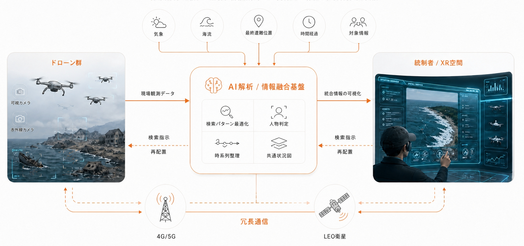
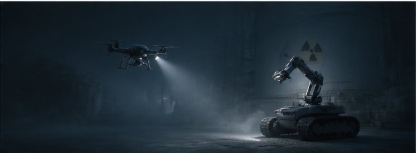
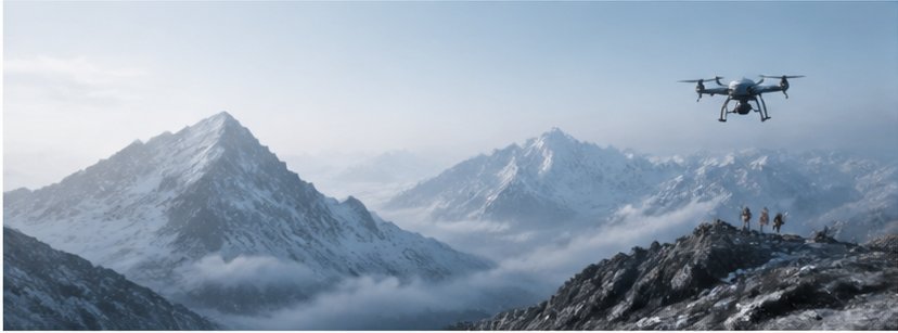
荒天・夜間・広大な海域での捜索にAIとドローンが対応。要救助者をリアルタイムで検知し、救助資源を最適配置します。
AI and drones handle searches across rough seas, at night, and over wide areas — detecting survivors in real time and optimizing rescue resource deployment.
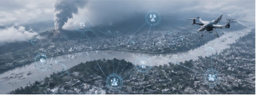
XRデバイスで現場映像・ドローンフィードを3次元統合可視化。指揮官はどこにいても状況認識を共有し、即時判断を下せます。
XR devices merge field imagery and drone feeds into a unified 3D view. Commanders share situational awareness and make immediate decisions from any location.
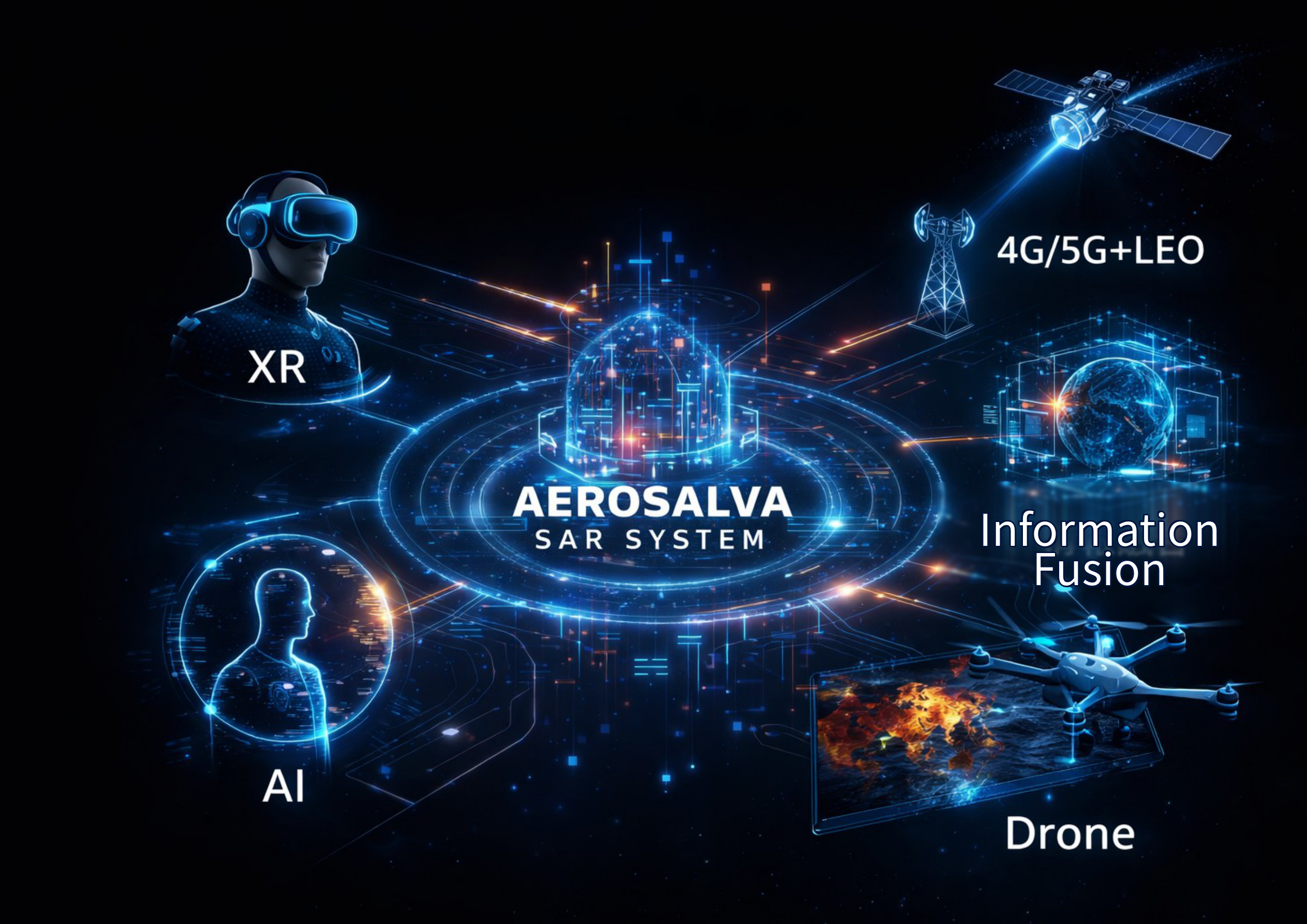
現場観測、通信、AI解析、情報融合、XR可視化を一体化し、統制判断を支援
Integrating field observation, communications, AI analysis, information fusion, and XR visualization to support command decisions
救助は、もっと早く、もっとシンプルにできる。
広大な捜索範囲、悪天候、限られた人員――現場には多くの制約があります。AEROSALVAは、AI・XR・ドローンの統合により、少人数で迅速に要救助者を特定し、救命率を高める新しい体制を実現します。
なぜ、今なのか。
- — LEO衛星通信の普及
- — AI解析の飛躍的向上
- — ドローンレベル4飛行の解禁
- — 政府方針(第4期海洋基本計画)
- — 海難事故増加・人員不足
技術・制度・社会課題が揃った今こそ、AEROSALVAが必要とされるタイミングです。
海上保安庁統計:国内で年間約1,800件の船舶事故(令和5年)。約97%が沿岸12海里以内、小型船舶が約8割を占める(令和6年版交通安全白書・内閣府)。
Rescue can be faster, and simpler.
Vast search areas, severe weather, limited personnel — the constraints are real. AEROSALVA integrates AI, XR, and drones to rapidly locate survivors with fewer resources, raising survival rates through a fundamentally new approach.
Why now?
- — Expansion of LEO satellite communications
- — Dramatic advances in AI analysis
- — Legalization of Level 4 drone operations
- — Japan's 4th Ocean Basic Plan
- — Growing accidents and personnel shortages
Technology, regulation, and social need have aligned. This is the moment AEROSALVA is needed.
JCG statistics: ~1,800 vessel accidents annually in Japan. ~97% within 12nm of coast; small vessels ~80% of total (Cabinet Office, FY2024).
準備中
「救える未来を、技術でつくる。」
私は30年以上、海上自衛隊のP-3C/P-1航空士として監視・災害・海難救助の任務に従事してきました。現場で感じたのは、「技術があれば救えた命がある」という現実。それが、AEROSALVAの原点です。
退官後は、宇宙・情報通信分野での実務経験を経て、2026年に株式会社AEROSALVAを設立しました。
"Building the future of rescue through technology."
I spent over 30 years as a JMSDF P-3C/P-1 aviation crew member, engaged in surveillance, disaster response, and maritime rescue missions. What I experienced in the field was a painful reality: lives that could have been saved, if only the technology had been there. That is the origin of AEROSALVA.
After retirement, I built experience in the space and information communications fields before founding AEROSALVA Inc. in 2026.
現在はシード期にあり、事業推進に必要な人材・機材等を確保するための資金調達を進めています。本事業の取組みにご賛同いただける方々からのご支援・ご協力をお待ち申し上げております。
We are currently in the seed stage, raising funds to secure the personnel and resources needed to advance our mission. We warmly welcome the support of those who share our vision.
設計思想は、登録特許に記録されています。
Our design philosophy is protected in registered patents.
これらが一体となり、捜索救難のスピードと精度を飛躍的に向上させます。
Together, these capabilities dramatically improve the speed and precision of search and rescue.
各項目をタップすると設計思想をご覧いただけます。
Tap each element to explore the design philosophy.
XRデバイスを装着したオペレータがメタバース空間を経由してドローンを操縦します。メタバース空間には僚機となる他のドローンの状況やAI解析による情報が表示されます。
Operators equipped with XR devices control drones via metaverse space. The metaverse space displays the status of other drones and information from AI analysis.
気象・海流・最終遭難位置と時間などをインプットすることで、AIが複数ドローンの最適捜索パターンと優先捜索エリアを算出します。時間経過とともに捜索エリアを再算出し、存在エリアをリアルタイムで更新し続けます。また、現場の複数ドローンに搭載されたセンサーから得られる情報をAIが解析し、人物等の閾値判定を行います。人の判断を否定するのではなく、データによる客観的な根拠を統制者に提供することが設計の目的です。
By inputting weather, ocean current, last known distress position, and elapsed time, AI calculates the optimal search pattern and priority search areas for multiple drones, continuously recalculating and updating probable presence zones in real time. AI also analyzes data from sensors mounted on multiple field drones to perform threshold-based detection of persons and objects. The design goal is not to override human judgment, but to provide commanders with objective, data-driven evidence to support their decisions.
ドローンには可視カメラ・赤外線カメラが搭載されており、LTE/LEO衛星通信経由でAIサーバーへ送信されます。
Drones are equipped with visible light and infrared cameras, transmitting data to the AI server via LTE/LEO satellite communications.
4G/5G地上通信とLEO衛星通信を組み合わせた冗長構成により、現場と統制所間の情報の途切れをなくすことを設計目標としています。この多重経路構成は特許JP7759154に基づいています。
A redundant configuration combining 4G/5G terrestrial communications with LEO satellite communications aims to eliminate information gaps between the field and command center. This multi-path architecture is based on Patent JP7759154.
現在の捜索救難では、現場にいる人・船・航空機等の情報がリアルタイムに共有されておらず、また統制者に届く情報は断片的で時系列も整っていないため、状況判断や適切な指示が困難です。AEROSALVA SAR SYSTEMはこれらの情報を統合・整理し、統制者がリアルタイムで状況を把握できる環境を提供することを設計目標としています。
In current SAR operations, information on personnel, vessels, aircraft, and other assets in the field is not shared in real time, and information reaching commanders is fragmented and poorly sequenced — making situational assessment and appropriate direction extremely difficult. AEROSALVA SAR SYSTEM is designed to integrate and organize this information, providing commanders with a real-time operational picture.
気象・海流・遭難推定時刻・最終確認位置等の環境データをインプットし、テンソル分解とニューラルネットワークを用いたAI解析により最適捜索パターンを導出。VRディスプレイとメタバース空間を通じて遠隔地からリモート操縦によるドローン飛行を実現するとともに、統制者は各ドローンの収集情報とAI解析データをリアルタイムにメタバース空間上で観察し、適時適切に現場等へ指示を行うことを可能とする設計を権利化。
Environmental data — including weather, ocean currents, estimated time of distress, and last confirmed position — is input for AI analysis using tensor decomposition and neural networks to derive optimal search patterns. The system enables remote drone flight via VR display and metaverse space, while commanders observe sensor data and AI analysis in real time within the metaverse environment and issue timely, appropriate instructions to on-site response teams. This integrated design is protected under the registered patent.
可視光・赤外線・レーザーセンサーの3種マルチセンサー情報をAIが解析し、人体形状確信度・色彩・体温・総合スコアの4閾値判定により要救助者の存在エリアを特定。JP7741598の分割特許。
AI analyzes input from three sensor types — visible light, infrared, and laser — applying four threshold determinations (body shape confidence, color, body temperature, and composite score) to identify the probable location of persons requiring rescue. Registered as a divisional of JP7741598, this patent independently protects the sensor-based detection function.
AEROSALVAは、AI・XR・自律運用・マルチセンサー・LEO衛星通信を統合した
次世代型捜索救助システムに関する基盤特許を保有しています。
・特許第7741598号
・特許第7759154号
・AIによる割当ドローン最適飛行パターンの生成
・AIによる最適捜索エリアの算出
・可視光+赤外線+レーザーのマルチセンサーAI解析
・VR/メタバースによる遠隔操縦・AI自動飛行モード
・3モード自動制御(手動操縦/AI自動飛行/安全帰投)
・5G/6G+LEO衛星通信の冗長構成
・マルチドローン協調制御
本特許はPCT国際出願済みであり、世界153か国で権利化が可能な状態です。
AEROSALVA holds foundational patents for next-generation Search & Rescue systems integrating AI, XR, autonomous operation, multi-sensor fusion, and LEO satellite communication.
- JP 7741598
- JP 7759154
- Autonomous multi-UAS mission orchestration and optimal flight-path generation
- AI-based optimal search area estimation
- Multi-sensor AI detection (Visible + IR + LiDAR)
- VR/Metaverse-based remote operation and AI autonomous flight mode
- Three-mode automatic control (Manual / AI Autonomous Flight / Safe Return)
- Resilient communication architecture with 5G/6G and LEO satellite network redundancy
- Multi-drone cooperative control
This patent has been filed under the PCT, enabling potential protection in 153 countries worldwide.
AEROSALVA SAR SYSTEMで培ったAI・XR・ドローン・通信・情報融合の技術は、捜索救難だけにとどまらず、さまざまな領域で応用可能な"基盤技術"です。私たちは、将来以下の分野への展開を見据えています。
The technologies developed through AEROSALVA SAR SYSTEM — AI, XR, drones, communications, and information fusion — are not limited to search and rescue. They represent a "core technology platform" applicable across a wide range of domains. We are working toward expansion into the following fields.
衛星・宇宙ステーション・月面基地など、遠隔地での作業支援・状況把握・自律運用に応用可能。XRとAIによる"地上からの統制"は、宇宙作業の安全性を高めます。
Applicable to remote task support, situational awareness, and autonomous operations in satellites, space stations, and lunar bases. XR and AI-powered "ground-based control" enhances the safety of space operations.
洋上風力、海底資源、海洋観測など、広域・高リスク環境での遠隔監視・点検に活用できます。ドローンとLEO通信の組み合わせは海上インフラの新標準となり得ます。
Applicable to remote monitoring and inspection in wide-area, high-risk environments such as offshore wind, seabed resources, and ocean observation. The combination of drones and LEO communications could become the new standard for marine infrastructure.
橋梁・ダム・トンネル・送電線など、危険区域の点検を遠隔・自動化することで、作業員の安全性を高め、効率的な維持管理を実現します。
By enabling remote and automated inspection of hazardous areas such as bridges, dams, tunnels, and power lines, this technology enhances worker safety and enables efficient infrastructure maintenance.
高放射線・高温・有害物質など、人が立ち入れない環境での遠隔観測・AI解析・ロボティクス統制に応用可能。安全性向上に大きく貢献します。
Applicable to remote observation, AI analysis, and robotics control in environments inaccessible to humans — such as high radiation, extreme heat, or hazardous materials. This contributes significantly to improved safety.
山岳地帯の遭難は、天候・地形・視界の悪さが大きな障害となります。AEROSALVAの技術は、広域捜索・位置特定・遠隔支援を可能にし、山岳救助の新しい形をつくります。
Mountain rescue is severely challenged by weather, terrain, and poor visibility. AEROSALVA's technology enables wide-area search, precise location identification, and remote support — creating a new model for mountain rescue operations.
地震・洪水・土砂災害など、複雑な状況下での情報統合・広域監視・迅速な判断支援に活用できます。"災害の可視化"は、行政・自治体の意思決定を支えます。
Applicable to information integration, wide-area monitoring, and rapid decision support in complex scenarios such as earthquakes, floods, and landslides. "Visualizing disaster" supports decision-making by government and local authorities.
| 商号 | Company Name | 株式会社AEROSALVA AEROSALVA Inc. |
|
|---|---|---|---|
| 設立 | Founded | 2026年3月17日 | |
| 代表取締役 | CEO | 澤谷 範之 Noriyuki Sawaya |
|
| 事業内容 | Business | XR・AI・ドローン・4G/5G・LEO衛星を統合した次世代SARシステムの研究開発・販売 | Research, development, and sales of next-generation SAR systems integrating XR, AI, drones, 4G/5G, and LEO satellites |
| 所在地 | Address | 〒105-0001 東京都港区虎ノ門1丁目15番10号 名和ビル4階 | Nawa Building 4F, 1-15-10 Toranomon, Minato-ku, Tokyo 105-0001, Japan |
| 電話番号 | Phone | 090-6001-7444 | |
| 連絡先 | Contact | contact@aerosalva.com | |
| 保有特許 | Patents |
JP 7741598 JP 7759154 澤谷IPマネジメントオフィスとの間で独占的通常実施権契約を締結。 |
|
| 国際出願 | International | PCT国際出願済 | PCT International Filing Completed |
| 代表者略歴 | CEO Profile | 元海上自衛隊 P-1/P-3C哨戒機航空士(2023年定年退官)2026年3月 株式会社AEROSALVA設立 | Former JMSDF P-1/P-3C aviation crew member (retired 2023). Founded AEROSALVA Inc. in March 2026. |
株式会社AEROSALVA(以下「当社」)は、お客様の個人情報の保護を重要な責務と認識し、以下のとおりプライバシーポリシーを定めます。
当社は、お問い合わせフォーム・メール等を通じて、氏名・メールアドレス・所属組織・お問い合わせ内容などの情報を取得する場合があります。また、Googleアナリティクスを使用してウェブサイトの利用状況(アクセス数・閲覧ページ等)を収集しています。
取得した個人情報は、お問い合わせへの回答・事業に関するご連絡・サービス改善のための分析にのみ使用します。第三者への提供は、法令に基づく場合を除き行いません。
当サイトはGoogleアナリティクスを使用しており、Cookieを通じてアクセス情報を収集します。収集データはGoogle社のプライバシーポリシーに従って管理されます。ブラウザの設定によりCookieを無効にすることができます。
個人情報の漏洩・滅失・毀損を防ぐため、適切な安全管理措置を講じます。
ご本人から個人情報の開示・訂正・削除のご要望がある場合は、下記の連絡先までお申し出ください。合理的な期間内に対応いたします。
株式会社AEROSALVA
東京都港区虎ノ門1丁目15番10号 名和ビル4階
Email:contact@aerosalva.com
制定:2026年3月17日
AEROSALVA Inc. ("the Company") recognizes the protection of personal information as an important responsibility and establishes the following Privacy Policy.
We may collect personal information such as name, email address, organization, and inquiry details through contact forms or email. We also use Google Analytics to collect website usage data (page views, access counts, etc.).
Collected personal information is used solely for responding to inquiries, business communications, and service improvement analysis. We do not share information with third parties except as required by law.
This website uses Google Analytics, which collects access information via cookies. Collected data is managed in accordance with Google's Privacy Policy. You may disable cookies through your browser settings.
We implement appropriate security measures to prevent unauthorized access, loss, or damage to personal information.
If you wish to access, correct, or delete your personal information, please contact us at the address below. We will respond within a reasonable time.
AEROSALVA Inc.
Nawa Building 4F, 1-15-10 Toranomon, Minato-ku, Tokyo 105-0001
Email: contact@aerosalva.com
Established: March 17, 2026